Trump has mooted that Gaza should be redeveloped – a motion for which he has been mocked and many conspiracy theories have sprung up about his suggestion, such as ‘ethnic cleansing’. However, what is demonstrated here is a lack of imagination, or will, from the detractors. People would rather criticise than use their imagination. To prove the possibility of there being, as Trump claims, a redevelopment solution, I am providing one.
Background
Currently, some sort of solution is needed for the area of Gaza occupied by the Palestinians. Several ideas have been ventured on how the area could be rebuilt but none seem to offer a longer-term solution.
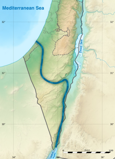
The Ben Gurion Canal was a proposed waterway project named after Israel’s founding father, David Ben-Gurion. Conceived in the 1960s, it aims to connect the Red Sea to the Mediterranean Sea via the southern end of the Gulf of Aqaba, providing an alternative route to the Suez Canal route and potentially reshaping regional maritime trade dynamics. (See diagram)
· My solution is similar but different in one important aspect – the canal will exit IN the south of Gaza.
As the Palestinians (and possibly others) won’t accept a name such as “Ben-Gurion”, we’ll call it a name acceptable to all: the ‘Michael Plan' – after the ‘Archangel Michael’ mentioned in the Torah, Quran and Bible.
Objectives:
1. To establish a new and improved environment for the Palestinian people that provides tangible benefits to both them and the people of Israel.
2. To foster a new mindset among the people of Gaza, replacing their current feelings of hopelessness, despair and rage, which are exploited by Hamas.
3. To enhance the prosperity of the Gazans and both the security and prosperity of Israel and safeguard international trade.
Broad Outline:
1. To create a “Port city of Gaza” that stands at the head of an international canal linking the Mediterranean Sea to the Red Sea. At the other end of the canal is the Israeli port city of Eilat.
2. The building of the canal will achieve several objectives:
a. It will provide jobs during the construction period (seven to ten years) and, once completed, offer permanent employment and income opportunities for both Israelis and Palestinians.
b. The canal will symbolically and in practical terms create a commercial and cooperative necessity between Israelis and Palestinians, fostering a change in attitudes and behaviours.
i. These benefits will not be available to Hamas interests; in fact, the absence of Hamas involvement will be a prerequisite. This project is for the Palestinian people of Gaza.
ii. The project can serve as both a commercial and political lever.
iii. The canal will form a ‘Maginot Line’ between Israel and Egypt and, for its final stretch, entirely between Gaza and Egypt. A barrier which cannot be easily crossed or tunnelled under, serving as a security barrier beneficial to both Israel and Egypt.
iv. The canal itself can act as a marine point of entry from Israel to Gaza, should the need arise.
3. On the Israeli/Gaza side of the canal will be solar farms and desalination plants.
a. The solar farms (and other structures) will provide energy for:
i. desalination and
ii. the port cities and surrounding environments.
iii. These structures can also act as physical barriers.
4. The project can be financed in several ways:
a. Partly through the United Nations, particularly through UNRWA under a new administration!
b. Partly by Israel
c. Partly by the US (which is currently making noises about wanting to resolve the current situation in Gaza)
d. Partly by funds taken from the Hamas leaders in Qatar (they are said to have billions squirreled away – it seems only fit that they should contribute)
e. Partly by the international community as they will receive the benefit of an alternative international trade route
f. Partly by the Arab nations as they have a direct interest in regional harmony
g. Partly by the self-funding nature of such a canal.
5. Management of the project will be by America MILITARY because the US will probably provide the ‘lion’s share’ funding and has the engineering capability and the ability to defend the project if needs be. Also, it will probably be unacceptable and contentious for the two warring parties (Palestinians and Israel) to co-manage.
a. The ports and canals are managed by the nations within whose territory those assets lie, i.e., the “Port of Gaza” by the Palestinians, and the “Port of Eilat” by the Israelis – with those sections of the canal in the respective territories being under the management of the respective authorities.
b. Multiple sections of the canal will be built and developed simultaneously to draw as much labour and people as possible from the currently ruined Gaza strip to both promote the project and take some pressure off the area.
i. This will also reduce Hamas manpower and increase the amount of emotional investment of Gazans in the project.
ii. During the period of construction and on-site grounds, military law (by the Americans) will be in force because Hamas will doubtless not be happy to see a coexistence and commensal relationship between the Gazans and Israel being established…
Given the current delays and the ongoing deaths in Gaza, now is an opportune moment to introduce the ‘improved’ canal idea. This new proposal includes a deviation that shortens the canal by 50km and creates a port management and trade enclave for the Gazans. We should gauge renewed interest from the involved parties and engage other stakeholders who have a vested interest in achieving peace in the Middle East and are open to exploring an alternative trade route. This proposal seems to be a viable option.
Appendix 1
Diagram of the original proposed path of the Ben Gurion Canal.
The blue line is the original proposal – in my proposal the canal would be 50km shorter and more direct and exit to the Mediterranean Sea by traversing the southernmost area of Gaza, and exit there, and thus act as an additional level of security for Egypt (and Israel) and provide the opportunity to build a new “Gaza Port” city. (The canal would now be about 207km long, instead of 257km long, and would take seven to 10 years to build.